
Interaction Design / UX Research / Tangible Product

About
This outdoor adventure game helps to regain trust in your orientation skills in an interactive and fun way.
My Role
Lead UX/UI Designer in a team of 4
Tools
Illustrator, Photoshop, Notion, Google Forms, Pen & Paper
In A Nutshell

Background
Nowadays we use often navigation systems to orientate and many people are no longer able to find their way without one. Because the way in which modern navigation devices guide people to their destination ensures that their orientation skills deteriorate.
Starting Thoughts..
We wanted to help people regain confidence in their orientation skills without turning the task into another boring learning habit.

Solution
An interactive outdoor group game for young adults that strengthens subconscious orientation skills in a playful way. Compared to other outdoor games, we use storytelling and interactive components to engage the user and encourage them to try out new paths.
Like Pokemon Go, but for learning while playing
Interested in more?
Check out our full design process
RESEARCH
Interviews & Competitor Analysis
I conducted 10 street interviews and 2 expert interviews to narrow down a possible problem in the area of navigation.
Street Interviews
We wanted first to get an overall feeling of people's own perception of their cognitive orientation abilities.
Main Insights
The findings show that more than half of the participants using their navigation system on the phone or in the car even though they allegedly trust their own sense of orientation. The navigation system then functions more like a back up to feel even more secure.
"I mostly use the GPS to double-check."
"I just let it run in case I make a wrong turn."
According to the participants, it is mainly used when they have to cover longer distances, when they are in a foreign city or when they don't know where they have to go. Some also say out of convenience.
"I don’t really need it around here, but in unfamiliar places it’s super helpful."
"It’s just more convenient, so I often use it even if I sort of know the way."
Not An Isolated Case
I found similar results in a 2020 study published in the journal Scientific Reports. The researchers found that those who used GPS more often had worse spatial memory when trying to navigate without navigation systems. When 13 of the participants were retested 3 years later, more frequent GPS usage was associated with worse spatial memory.
Expert Interviews
In order to dive deeper into the process of how psychological processes take place during orientation and how these can be positively influenced, we conducted two interviews with the following experts.

Dr. Julia Frankenstein from the technical university in Darmstadt, Germany. Specialized in psychology of human spatial representations and spatial memory retrieval and its use for navigation.

Prof. Dr. Stefan Münzer from the university of Mannheim, Germany - specialized in psychology of multimedia learning with focus on Spatial Structures, Orientation and Navigation.
The Key Principle
The topic of orientation from a psychological point of view is huge and I can't list the overwhelming amount of information we got from the expert interviews here. But what is important to mention is the key principle of orientation, on which we will build our design later.

A navigation device can only teach route knowledge. However, the cognitive map we use in our head for orientation is not a city map. It is a mental and subjective representation of how places lie spatially in relation to each other.

It consists of fragments and landmarks that have an inherent orientation. If it is not trained, it regresses. However, the skill can also be trained again.
Conclusion
The problem is not that we use navigation systems for orientation, but HOW we use them.
How To Solve this?
In order to agree on an idea during the brainstorming session, we asked ourselves the following questions.
"How can we encourage people to train their orientation skills without it becoming too theoretical?"
"How can we teach orientation without a realistic map?"
"How make the users wanna come back?"
"Who would pay for such a product?"


Our Solution
Creating an outdoor adventure game whose aim is to train the sense of direction by creating a mental map of the environment. Embedding this adventure in an interactive story that can be physically experienced outside in small groups or alone. The users take on, e.g., the role of detectives and must solve a mystery in the city. Fun and entertainment should be the main priority for the users, while the acquisition of orientation skills is to be practiced unconsciously.
A quick competitor analysis heto determine the pros and cons of other similar interactive games. From there, we analyzed the findings from the research to identify the product requirements.
Competitor Analysis


Jobs-To-Be-Done
-
Create incentives to move to one's destination without the help of navigation systems.
-
Teach, promote and train techniques for creating a mental map so that people have the opportunity to move without a navigation system in the first place.
-
Restore confidence in one's own sense of direction so that the user also makes use of it.
-
Prevent the use of a navigation system out of habit or convenience.
CONCEPT
User Flows & Product Components
Using my findings from the research phase, I created
3 user archetypes to represent users with different backgrounds and needs.
Our Archetypes
Click on the different archetype to find more out about them.


Heroes Journey
In addition to the archetypes I created a hero's journey and user flow for the game main functions. I wanted to understand how my users would complete a function and what they would need to accomplish it.

User Flow

Main Product Component
In order to accomplish the puzzles and tasks that appear in the storyline, users are given a device - the "Adventure Log" -attached to an elastic adjustable bracer that you put on during the game.


"Why did you not just made an app?"
It was important that the device is not just the user's smartphone, but something with which the user can better empathize with his role and also to integrate body prominence into the task solution, which is an important component to gain orientation skills, as we found out in our research.

How To Use The Device
If the player is not in a task, the display shows him a simplified map of the area with landmarks and task points.
Map with unknown area and already discovered landmarks and tasks:

The user has successfully discovered the location of the last landmark:

Using symbols and vibrations, the user is informed when a new task needs to be completed and what exactly needs to be done.
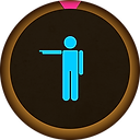
Point
Users must estimate the location of a landmark or last visited point by physically pointing the Adventure Log in the direction of the landmark. The task is considered solved when the estimation direction is within a tolerance range defined for the task.
Draw
At a task location, players must draw a personal symbol as a landmark on the display. The task is considered solved when the group has drawn the landmark within a tolerance radius defined for the task.
Scan
Players must locate a surrounding NFC-tag at a specific landmark and scan it with the adventure log. The task is considered solved when the players have found the tag and scanned it with the device.
Lessons Learned
-
Time and reliability are key factors
Dependence on weather or a good reception network would negatively impact the gaming experience. As a result, time and reliability have become a key component.
-
Storytelling is at the center of the user experience
In the project, we kept noticing that users mainly focus on the storyline. Therefore, making the game easy to understand and use and the location features were important elements of the process.
-
Good teamwork brings better results
My coordination of the team made everyone feel comfortable and every opinion was heard and respected. Compared to other team projects I had, I could observe how this positively benefited the project result.